One of the best ways to experience the Crescent City, Brookings, and Redwood Coast region is from the road. Scenic drives allow travelers to move through several dramatically different environments in a single day.
A morning drive may pass beneath ancient redwoods. An afternoon route may follow rocky cliffs above the Pacific Ocean. Between those landscapes, travelers may encounter wild rivers, coastal prairie, beaches, harbors, offshore rocks, forest overlooks, wildlife, fern-covered trails, fog, historic roads, and small coastal communities.
The region is especially well suited to travelers who prefer shorter walks, are traveling with children, have limited mobility, want a rainy-day activity, enjoy photography, want to see several attractions in one day, prefer flexible sightseeing, or are staying multiple nights at White Rock Resort.
Several roads deserve special attention: Howland Hill Road, Newton B. Drury Scenic Parkway, U.S. Highway 101 between Crescent City and Brookings, Samuel H. Boardman State Scenic Corridor, Smith River and U.S. Highway 199 routes, Bald Hills Road, and coastal routes south toward Prairie Creek and Orick.
Each drive has different road conditions, vehicle limitations, scenery, and time requirements. This guide explains the best scenic drives near White Rock Resort and how to enjoy them safely.
Why Scenic Driving Works So Well on the Redwood Coast
The Redwood Coast is not built around one single attraction. Its beauty is spread across forests, rivers, beaches, scenic corridors, state parks, national and state park lands, harbors, overlooks, small communities, and wildlife habitat.
Driving connects these areas. A scenic-drive day can be adapted to weather, energy level, children's needs, mobility, daylight, wildlife activity, and restaurant plans.
Travelers can stop frequently or remain in the vehicle for most of the day.
Howland Hill Road
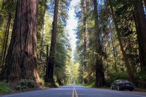
Howland Hill Road is one of the most immersive redwood drives near Crescent City. It passes through Jedediah Smith Redwoods State Park in the northern portion of Redwood National and State Parks. The route is approximately ten miles long and is primarily narrow and unpaved.
The National Park Service describes it as a road where the redwoods come extremely close to the vehicle and advises that recreational vehicles, trucks, and vehicles towing trailers are too wide for it.
Towering Redwoods
Experience massive old-growth trees from a historic forest road.
Dense Forest
Travel through greenery, fern-covered slopes, and enormous tree trunks.
Short Walks
Combine the drive with appropriate short trail opportunities.
Slow Travel
The narrow road is best enjoyed at a relaxed pace rather than treated as a shortcut.
What Makes Howland Hill Road Special?
Many major highways pass beside redwood forests. Howland Hill Road travels directly through them. The road feels narrow because large trees stand close to the roadway, the route winds through dense forest, shoulders are limited, visibility may be restricted around curves, and passing space can be limited.
The slower pace is part of the experience. This is not a road to rush.
How Long Does Howland Hill Road Take?
The National Park Service generally recommends allowing approximately 45 to 90 minutes for the drive, depending on traffic, stops, and road conditions.
Travelers may need more time if they stop for photographs, walk a trail, wait for another vehicle to pass, encounter maintenance work, travel after rain, visit Stout Grove or the Grove of Titans area, or have young children.
A leisurely half-day may be more enjoyable than treating the road as a shortcut.
Which Vehicles Should Avoid Howland Hill Road?
- Recreational vehicles.
- Trailers.
- Large trucks.
- Wide vans.
- Drivers uncomfortable with narrow roads.
- Drivers who dislike unpaved surfaces.
- Vehicles with limited clearance when conditions are poor.
Important Vehicle Reminder
The National Park Service specifically states that RVs, trucks, and vehicles with trailers are too wide for Howland Hill Road. Use a normal passenger vehicle and confirm current conditions before entering.
Is Howland Hill Road Paved?
Only portions of the route are paved. Official park directions describe the road as becoming unpaved after entering Jedediah Smith Redwoods State Park and continuing through the forest before connecting with other local roads.
- Dust during dry weather.
- Mud after rain.
- Potholes.
- Washboarding.
- Fallen branches.
- Standing water.
- Narrow passing areas.
Drive slowly and follow current closure or maintenance signs.
Howland Hill Road Safety
Suggested Stops Along Howland Hill Road
- Stout Memorial Grove.
- Grove of Titans.
- Smith River viewpoints.
- Short forest walks.
- Photography stops.
- Picnic areas.
- Jedediah Smith Redwoods State Park facilities.
Parking may be limited at some trailheads, and RVs or trailers may not be permitted in certain areas. Do not park outside designated areas.
Newton B. Drury Scenic Parkway
Newton B. Drury Scenic Parkway is one of the premier paved redwood drives in Northern California. It runs through Prairie Creek Redwoods State Park and extends for approximately ten miles through old-growth redwood forest.
The National Park Service states that vehicles of any size may use the parkway and recommends allowing at least twenty minutes without stops, although most visitors should plan considerably longer.
Paved Road
A comfortable option for travelers who prefer a paved scenic drive.
Old-Growth Forest
Travel directly through impressive Prairie Creek redwood scenery.
Wildlife
Possible Roosevelt elk viewing near meadows and forest openings.
Trail Access
Combine the drive with short walks, picnic stops, and forest exploration.
Why Leave Highway 101?
Travelers driving only on Highway 101 may miss some of the most impressive old-growth scenery. Newton B. Drury Scenic Parkway exits the main highway and travels directly through the heart of Prairie Creek's redwood forest.
The National Park Service encourages visitors with only one opportunity to see redwoods not to miss this drive. The road later reconnects with Highway 101.
How Long Should You Allow?
The parkway itself may be driven in approximately twenty minutes without stopping. A more realistic visit may take:
30–60 Minutes
A basic scenic-drive experience.
2–3 Hours
Drive combined with short trails.
Half Day
Elk viewing, picnic stops, and redwood exploration.
Full Day
Combine with Orick, Gold Bluffs Beach, or other nearby attractions.
Roosevelt Elk Along the Parkway
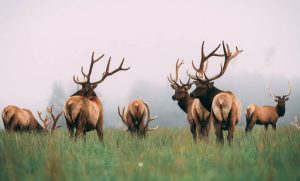
The parkway passes through Prairie Creek Redwoods State Park, one of the region's strongest Roosevelt elk habitats. Visitors may see elk near Elk Prairie, meadow edges, visitor-center areas, forest openings, and nearby roads.
Elk sightings are never guaranteed. If elk appear:
- Use designated parking.
- Remain at least 25 yards away.
- Use binoculars.
- Keep children close.
- Keep pets controlled.
- Never block the road.
- Do not approach for photographs.
Recommended Stops on Newton B. Drury Scenic Parkway
- Prairie Creek Visitor Center.
- Elk Prairie.
- Big Tree Wayside.
- Trillium Falls area.
- Prairie Creek Trail access.
- Short redwood walks.
- Picnic areas.
- Wildlife-viewing locations.
The Prairie Creek Visitor Center is located directly on Newton B. Drury Scenic Parkway and is a useful starting point for trails, elk viewing, and redwood exploration. Confirm current hours before relying on visitor-center services.
U.S. Highway 101 Between Crescent City and Brookings
The stretch of U.S. Highway 101 between Crescent City and Brookings provides a convenient coastal drive near White Rock Resort. Depending on the direction and selected stops, travelers may experience Pacific Ocean views, forested hills, Smith River country, beaches, state recreation sites, Brookings Harbor, Harris Beach, coastal headlands, and small communities.
This route is paved and generally appropriate for standard passenger vehicles, larger vehicles, and RVs, although individual pullouts and side roads may have limitations.
Best Stops Between Crescent City and Brookings
- Coastal viewpoints.
- Smith River overlooks.
- Public beaches.
- Harbor areas.
- Harris Beach State Park.
- Winchuck River area.
- McVay Rock.
- Brookings Harbor.
- Downtown Brookings.
- Chetco River viewpoints.
The south end of Samuel H. Boardman State Scenic Corridor begins only a few miles north of Harris Beach, allowing travelers to extend the drive beyond Brookings.
Crescent City to Brookings as a Half-Day Drive
Head Toward Brookings
Depart White Rock Resort, stop at one or two public coastal viewpoints, and continue toward Brookings.
Explore Brookings
Visit Brookings Harbor, eat lunch, and walk a short public path.
Return via Harris Beach
Stop at Harris Beach and return to White Rock Resort.
This route works well for families, older adults, rainy days, travelers who prefer short walks, and guests arriving or departing that day.
Samuel H. Boardman State Scenic Corridor
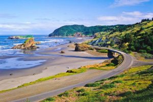
Samuel H. Boardman State Scenic Corridor is one of the most dramatic coastal drives in Southern Oregon. The corridor follows approximately twelve miles of Highway 101 between Brookings and Gold Beach and contains a series of scenic viewpoints, beaches, forested trails, and offshore rock formations.
Sea Stacks
Offshore rocks and dramatic coastal formations create memorable viewpoints.
Ocean Cliffs
Forested headlands rise above broad Pacific views.
Hidden Coves
Selected viewpoints and trails lead toward secluded coastal scenery.
Short Trails
Combine driving with established walking routes appropriate for your group.
Why Samuel H. Boardman Is Special
The corridor feels like a sequence of separate scenic experiences rather than one single park. Drivers may stop at multiple waysides along Highway 101. Some stops offer immediate overlooks, picnic tables, short walks, beach access, and elevated ocean views.
Oregon State Parks describes the corridor as a series of scenic waysides, with some providing picnic tables and exceptional ocean views.
How Long Should You Allow?
The road segment itself is relatively short. However, scenic stops can easily fill two to three hours, half a day, or a full day.
Time depends on the number of stops, trail length, photography, weather, parking availability, beach access, crowds, and children's needs.
Do not attempt every stop in one rushed visit. Choose several and return another day if time permits.
Popular Samuel H. Boardman Stops
- Arch Rock.
- Natural Bridges.
- Secret Beach access areas.
- Thunder Rock Cove.
- Indian Sands.
- Cape Ferrelo.
- House Rock viewpoints.
- Whaleshead area.
- Lone Ranch Beach.
Access, parking, and trail conditions can change. Some locations require steep or uneven walking. Remain on established trails.
Natural Bridges Safety
A Photograph Is Never Worth the Risk
Natural Bridges and other coastal viewpoints can contain serious cliff hazards. Stay within established public viewing areas and never enter an unstable or restricted area for a photograph.
Samuel H. Boardman Vehicle Considerations
Highway 101 is paved and suitable for most vehicles. However:
- Some pullouts are small.
- Parking may fill.
- Turning space may be limited.
- Large RVs may not fit comfortably at every stop.
- Drivers should avoid abrupt braking.
- Pedestrians may cross near trailheads.
- Fog may reduce visibility.
If a parking area is full, continue to another stop rather than parking illegally.
Smith River and U.S. Highway 199
U.S. Highway 199 travels northeast from Crescent City through Smith River country toward Hiouchi and beyond. This route offers river views, forested canyon scenery, access to Jedediah Smith Redwoods State Park, swimming and picnic areas during suitable conditions, connections to Howland Hill Road, short forest trails, and mountain and river landscapes.
This drive contrasts with the exposed coastal scenery found north of Brookings.
Why the Smith River Route Is Worth Driving
The Smith River is known for clear water and forested surroundings. Depending on season and conditions, visitors may enjoy:
- Scenic pullouts.
- River photography.
- Forest walks.
- Picnicking.
- Wildlife observation.
- Summer river access.
- Fall color in surrounding vegetation.
- Rainy-day forest scenery.
Water conditions can be dangerous. Never assume a calm-looking river is safe for swimming or wading.
Suggested Smith River Drive
- Depart White Rock Resort.
- Travel toward Crescent City.
- Continue east on U.S. Highway 199.
- Stop at legal river viewpoints.
- Visit an appropriate Jedediah Smith trail.
- Return by the same route or connect with Howland Hill Road if the vehicle and conditions are suitable.
Howland Hill Road should only be added after confirming that the driver and vehicle are appropriate for its narrow, mostly unpaved conditions.
Bald Hills Road
Bald Hills Road travels through the southern portion of Redwood National and State Parks. The National Park Service describes it as a scenic drive into high hills and open prairies, with opportunities for hiking, birdwatching, wildlife viewing, historic barns, and broad landscapes.
Open Prairie
Experience landscapes that contrast with dense old-growth redwood forests.
Wildlife
Look for opportunities to observe elk and birdlife from appropriate locations.
Historic Landscapes
Historic barns and changing elevations add variety to the route.
Long Views
The higher route provides broader landscapes than enclosed forest roads.
Is Bald Hills Road for Everyone?
No. The route may include narrow sections, curves, unpaved portions, limited services, remote areas, changing weather, weak or unavailable cell service, and seasonal road issues.
The National Park Service suggests allowing two to six hours, depending on the extent of the drive and planned activities. Travelers should confirm current road conditions before leaving.
Who May Enjoy Bald Hills Road?
The drive may appeal to:
- Wildlife photographers.
- Birdwatchers.
- Travelers seeking less-visited scenery.
- Experienced scenic-road drivers.
- History enthusiasts.
- Visitors with a full day available.
- Guests comfortable in remote areas.
It may be less suitable for:
- Large RVs.
- Drivers uncomfortable with narrow roads.
- Travelers with very limited time.
- Visitors driving in poor weather.
- Anyone without adequate fuel.
Crescent City to Prairie Creek and Orick
The drive south from Crescent City toward Prairie Creek and Orick offers a combination of coastal views, redwood forest, highway scenery, prairie habitat, elk-viewing opportunities, visitor centers, and trail access.
Travelers can leave Highway 101 for Newton B. Drury Scenic Parkway and later reconnect with the highway.
Redwood National and State Parks do not have a single entrance gate; many attractions and facilities are distributed along Highway 101, Newton B. Drury Scenic Parkway, and surrounding roads.
Suggested Crescent City to Prairie Creek Day
Head South
Depart White Rock Resort early, travel through Crescent City, continue on Highway 101, and enter Newton B. Drury Scenic Parkway.
Redwoods and Elk
Stop at Elk Prairie, visit Prairie Creek Visitor Center if open, and take a short redwood walk.
Take a Break
Picnic in an approved area or eat near Orick.
Return North
Continue through prairie and forest habitat, look for Roosevelt elk from a safe distance, and return before dark.
This drive combines redwoods, wildlife, and scenic roads without requiring a difficult backcountry route.
Brookings to Cape Sebastian
Travelers wishing to continue north beyond Samuel H. Boardman may drive toward Cape Sebastian. Oregon State Parks describes Cape Sebastian as having parking viewpoints more than 200 feet above sea level, with expansive coastal views that may extend many miles under clear conditions.
- Samuel H. Boardman viewpoints.
- Gold Beach.
- Elevated ocean vistas.
- Coastal forest.
- Whale-watching opportunities.
- Long-distance photography.
This is better suited to a full day than a short outing.
Best Scenic Drive for First-Time Visitors
Northern Redwood Loop
White Rock Resort → Crescent City → U.S. Highway 199 → Jedediah Smith Redwoods State Park → Howland Hill Road, if suitable → Crescent City.
This drive provides a concentrated old-growth experience close to the resort. For travelers who prefer paved roads, substitute a normal Highway 199 and Jedediah Smith route without entering Howland Hill Road.
Newton B. Drury Scenic Parkway
Newton B. Drury Scenic Parkway is generally the best choice for travelers seeking old-growth redwoods, paved driving, easy access, larger vehicle suitability, short trails, elk habitat, and picnic opportunities.
Howland Hill Road
Howland Hill Road offers the most intimate driving experience because the narrow road passes directly between enormous redwoods. It is best for standard passenger vehicles, confident drivers, dry or stable conditions, travelers comfortable driving slowly, and visitors who do not mind dust or mud.
It is not suitable for RVs, large trucks, or trailers.
Samuel H. Boardman State Scenic Corridor
Samuel H. Boardman State Scenic Corridor is one of the strongest coastal-driving choices. It provides rocky headlands, ocean overlooks, sea stacks, trail options, beaches, picnic areas, and photography opportunities.
Best Drive for Families
A family-friendly scenic-drive day may include:
- Crescent City.
- Smith River viewpoints.
- Jedediah Smith Redwoods State Park.
- One short trail.
- A picnic.
- A harbor stop.
- Return to White Rock Resort.
Families should avoid overloading the day with too many stops. Children often enjoy giant trees, river views, wildlife spotting, picnic areas, short walks, and beach breaks.
Best Drive for Older Adults
Older travelers may prefer:
- Highway 101.
- Newton B. Drury Scenic Parkway.
- Brookings Harbor.
- Samuel H. Boardman overlooks with nearby parking.
- Smith River scenic pullouts.
- Crescent City Harbor.
These routes allow substantial sightseeing without requiring long hikes. Confirm restrooms, parking, seating, path surfaces, accessibility, and current facility hours.
Best Drive for Limited Mobility
A scenic-drive itinerary can be one of the best ways for travelers with limited mobility to experience the coast and redwoods.
- Newton B. Drury Scenic Parkway.
- Crescent City Harbor.
- Brookings Harbor.
- Highway 101 viewpoints.
- Accessible coastal overlooks.
- Visitor-center stops.
- Smith River pullouts.
Accessibility varies by individual stop. Research each location before departure.
Best Rainy-Day Scenic Drive
Light rain can make the redwoods appear especially vivid. A practical rainy-day route may include Crescent City, U.S. Highway 199, Jedediah Smith Redwoods State Park, short stops at developed viewpoints, lunch in Crescent City, and harbor viewing.
Avoid:
- Forest roads during high winds.
- Cliff areas during heavy rain.
- Howland Hill Road if conditions appear poor.
- Flooded routes.
- Beach access during high surf.
Best Photography Drive
Coastal Light
Choose a coastal overlook near White Rock Resort or explore Crescent City harbor or lighthouse views from legal public areas.
Redwoods
Photograph Howland Hill Road or Jedediah Smith forest scenery.
Southern Oregon Coast
Explore Brookings and selected Samuel H. Boardman viewpoints.
Safe Coastal Overlook
Finish at a safe elevated coastal viewpoint with legal parking and a clear return route.
Do not rush between locations. Good light and safe parking matter more than the number of stops.
Best Wildlife Scenic Drive
A wildlife-focused route may include:
- White Rock Resort ocean viewing.
- Crescent City Harbor.
- Newton B. Drury Scenic Parkway.
- Elk Prairie.
- Orick.
- Coastal overlooks.
Possible wildlife includes:
- Roosevelt elk.
- Deer.
- Eagles.
- Osprey.
- Pelicans.
- Cormorants.
- Seals.
- Sea lions.
- Whales.
- Shorebirds.
Wildlife sightings are never guaranteed.
Scenic Driving With Children
Before leaving:
Children may become more engaged when asked to look for the largest tree, a river, an elk, a waterfall, a bridge, a sea stack, a pelican, a redwood stump, fog, or a lighthouse.
Scenic Driving With Dogs
- Confirm pet rules at every stop.
- Keep the dog leashed.
- Bring water.
- Carry waste bags.
- Never leave the dog in a hot vehicle.
- Keep away from elk.
- Avoid nesting birds.
- Prevent barking at wildlife.
- Check trail restrictions.
Pets are permitted in some developed areas and road corridors but may be prohibited from many park trails.
Scenic Driving in Fog
Fog is common along the Northern California and Southern Oregon coast. When fog develops:
- Reduce speed.
- Use low-beam headlights.
- Increase following distance.
- Avoid unnecessary passing.
- Watch for wildlife.
- Expect cyclists and pedestrians.
- Use pullouts safely.
- Do not stop in the roadway.
- Avoid cliffside walks with poor visibility.
Fog may improve forest photography but reduce ocean views. Be willing to change the itinerary.
Scenic Driving in Rain
Rain may create:
- Reduced visibility.
- Standing water.
- Mud.
- Fallen branches.
- Rockfall.
- Slippery roads.
- Flooded low areas.
- Poor trail conditions.
Drivers should:
- Slow down.
- Keep headlights on.
- Avoid sudden braking.
- Increase following distance.
- Confirm road conditions.
- Avoid crossing water.
- Respect closure signs.
- Carry emergency supplies.
Scenic Driving During High Winds
High winds are especially important in redwood forests and on coastal headlands. Potential hazards include falling branches, falling trees, road debris, vehicle instability, dangerous surf, and reduced control on exposed roads.
During wind warnings:
- Avoid forest drives.
- Avoid parking beneath large trees.
- Avoid cliff edges.
- Follow park and weather advisories.
- Choose indoor activities when necessary.
Checking Current Road Conditions
Before leaving White Rock Resort, check:
Oregon's TripCheck system provides current road, traffic, weather, incident, camera, and restriction information for Oregon routes. Conditions can change quickly.
Fuel and Services
Do not begin a long remote drive with a nearly empty fuel tank. Before traveling toward Bald Hills Road, Gold Bluffs Beach, remote Boardman stops, or less-developed redwood roads, confirm:
- Fuel level.
- Food.
- Water.
- Restrooms.
- Mobile service.
- Daylight.
- Route length.
Services may be limited outside Crescent City, Brookings, and other communities.
Mobile Service and Navigation
Cellular coverage may be limited in redwood forests, river canyons, remote coastal areas, Bald Hills, Samuel H. Boardman trailheads, and portions of Highway 199.
Before leaving:
- Download maps.
- Save addresses.
- Screenshot directions.
- Tell someone the route.
- Carry a paper map.
- Bring a charged portable battery.
Do not depend entirely on live navigation.
Parking Safely
Use only:
- Designated parking areas.
- Legal pullouts.
- Trailhead parking.
- Visitor-center lots.
- Public waysides.
Do not park:
- In travel lanes.
- On blind curves.
- In private driveways.
- On fragile vegetation.
- In front of gates.
- On narrow shoulders.
- Where signs prohibit stopping.
If a parking area is full, continue to another location.
Photography From the Road
Never photograph while driving. The driver must keep attention on curves, wildlife, pedestrians, cyclists, road surfaces, and oncoming traffic.
For photography:
- Use a designated pullout.
- Park completely.
- Check traffic before opening doors.
- Remain away from the roadway.
- Keep children supervised.
- Avoid cliff edges.
- Use a passenger as the photographer when appropriate.
Do Not Rush a Scenic Drive
The purpose is not to complete every road. Choose fewer places and spend more time at each.
A relaxed drive allows travelers to notice wildlife, enjoy changing light, stop safely, take short walks, eat without rushing, adapt to weather, and avoid fatigue.
Sample Half-Day Northern Redwood Drive
White Rock Resort to Jedediah Smith
Depart White Rock Resort, travel toward Crescent City, continue to Jedediah Smith Redwoods State Park, and stop at a developed river or forest area.
Howland Hill Road
Drive Howland Hill Road if the vehicle and conditions are suitable. Otherwise remain on paved roads.
Crescent City
Return to Crescent City for lunch or a harbor visit.
Return to White Rock Resort
Finish the half-day outing with a relaxed return to the resort.
Sample Full-Day Redwood Drive
Jedediah Smith Redwoods
Depart early, visit Jedediah Smith Redwoods State Park, and drive Howland Hill Road if appropriate.
Lunch
Continue through Crescent City and stop for lunch.
Newton B. Drury
Drive Newton B. Drury Scenic Parkway and stop at Elk Prairie.
This is a long day and should only be attempted when the group is comfortable with substantial driving.
Sample Brookings Coastal Drive
Harris Beach
Depart White Rock Resort, drive north toward Brookings, and stop at Harris Beach.
Brookings Harbor
Visit Brookings Harbor and eat lunch.
Samuel H. Boardman
Drive part of the scenic corridor, choose two or three viewpoints, and return before dark.
Sample Samuel H. Boardman Day
Enter the Corridor
Drive to Brookings, continue north, and stop at an easy overlook.
Second Viewpoint
Visit a second viewpoint and take a short established trail.
Picnic or Local Meal
Use an approved picnic area or eat in Brookings or Gold Beach.
Final Viewpoint
Visit one additional viewpoint and return south.
Do not attempt every trail or overlook in one day.
Sample Accessible Scenic Drive
Start at White Rock Resort
Watch the ocean from the resort and drive to Crescent City Harbor.
Highway 199
Travel east along Highway 199 and stop at developed viewpoints.
Crescent City
Eat lunch before continuing.
Coastal Route
Take a paved coastal drive toward Brookings and stop only where access is comfortable.
Sample Rainy-Day Drive
Check Conditions
Review weather, wind, and road alerts before driving toward Crescent City.
Harbor and Forest
Visit protected harbor areas, eat lunch, and travel along Highway 199 for forest scenery.
Return Early
Return to White Rock Resort and stop at developed viewpoints only if conditions remain safe.
Avoid remote unpaved roads during severe weather.
Questions to Ask Before a Scenic Drive
Common Scenic-Driving Mistakes
Oversized Vehicle on Howland Hill Road
RVs, trucks, and trailers are not appropriate for the road.
Trying to See Everything
Choose fewer destinations and enjoy them properly.
Starting With Low Fuel
Fill the tank before remote routes.
Depending Entirely on Cell Service
Download maps before leaving.
Stopping in the Road for Photos
Use legal pullouts.
Entering a Full Parking Area
Continue to another stop rather than parking illegally.
Ignoring Weather Alerts
Coastal and forest conditions can change quickly.
Driving Forest Roads During High Winds
Falling branches and trees can be dangerous.
Approaching Elk
Remain inside the vehicle or maintain substantial distance.
Following Navigation Onto an Unsuitable Road
Confirm routes with official information.
Driving Too Fast on Unpaved Roads
Expect potholes, dust, and limited visibility.
Returning After Dark
Allow time to complete remote roads in daylight.
Looking at Scenery While Driving
The driver must watch the road.
Assuming Every Overlook Is Accessible
Trail and surface conditions vary.
Leaving Valuables Visible
Secure belongings when leaving the vehicle.
Best General Recommendation for White Rock Resort Guests
For a first scenic-driving experience, choose one of these two options:
Redwood Day
- Crescent City.
- Highway 199.
- Jedediah Smith Redwoods State Park.
- Howland Hill Road if appropriate.
- Crescent City Harbor.
Oregon Coast Day
- Brookings.
- Harris Beach.
- Samuel H. Boardman State Scenic Corridor.
- Two or three selected overlooks.
- Brookings Harbor.
These routes provide very different experiences and are best enjoyed on separate days.
Scenic Drives Near Crescent City and Brookings
What is the best scenic drive near Crescent City?
Howland Hill Road is one of the most immersive redwood drives near Crescent City, while Highway 199 provides an easier paved route through Smith River country.
Is Howland Hill Road paved?
Much of the road is unpaved and narrow.
Can an RV drive Howland Hill Road?
No. The National Park Service states that RVs, trucks, and vehicles towing trailers are too wide.
What is the best paved redwood drive?
Newton B. Drury Scenic Parkway is an excellent paved route through old-growth redwoods.
Can large vehicles use Newton B. Drury Scenic Parkway?
Yes. Official park guidance states that vehicles of any size may use the parkway.
How long is Newton B. Drury Scenic Parkway?
Approximately ten miles.
What is the best coastal drive near Brookings?
Samuel H. Boardman State Scenic Corridor is one of the strongest coastal options.
How long is Samuel H. Boardman State Scenic Corridor?
Approximately twelve miles along Highway 101.
Can the Samuel H. Boardman corridor be completed in half a day?
Yes, when visitors select only a few overlooks or short trails.
Is scenic driving good during rain?
Yes, during light rain and safe road conditions. Avoid high winds, flooding, dangerous surf, and unstable forest roads.
Are scenic drives suitable for children?
Yes. Include short walks, snacks, restroom stops, and wildlife games.
Are scenic drives suitable for older adults?
Yes. Many routes provide significant scenery from the vehicle or nearby viewpoints.
Is cell service reliable?
No. Service may be limited in forests, canyons, and remote coastal areas.
Should we check road conditions?
Yes. Use official park alerts and Oregon TripCheck before travel.
Are elk visible from scenic roads?
Possibly, especially near Prairie Creek, Elk Prairie, Orick, and other suitable habitats.
Should we stop if wildlife appears beside the road?
Only when a legal and safe pullout is available.
Is Bald Hills Road suitable for every driver?
No. It is more remote and may involve narrow, unpaved, or changing road conditions.
What should we pack?
Bring water, food, layers, rain gear, offline maps, a charged phone, a portable battery, and a full fuel tank.
What is the most important scenic-driving rule?
The driver must focus on the road while passengers enjoy the scenery.
Plan the Experience, Not Just the Mileage
Do not evaluate a scenic drive only by the distance shown on a map. A ten-mile route may take an hour or more because of narrow roads, photography, wildlife, trail stops, limited parking, fog, road conditions, and slow-moving vehicles.
Plan scenic drives by experience rather than mileage. Choose one primary route. Add only a few stops. Leave enough time to sit quietly beneath the redwoods, watch the ocean, or wait for fog to move through the trees.
Related Articles
Explore the Redwood Coast From White Rock Resort
The scenic roads surrounding Crescent City and Brookings reveal the full variety of the Redwood Coast. Howland Hill Road brings travelers close to enormous old-growth trees. Newton B. Drury Scenic Parkway provides an accessible paved journey through Prairie Creek's redwood forest. Highway 199 follows the clear waters and forested landscape of the Smith River. Samuel H. Boardman State Scenic Corridor presents sea stacks, cliffs, beaches, and broad Pacific views. Bald Hills Road climbs into remote prairie and oak woodland. Highway 101 connects coastal communities, harbors, beaches, forests, and wildlife habitat.
Each route offers something different. Drive slowly. Check current conditions. Use the right vehicle. Remain on legal roads. Stop only in safe locations. Respect wildlife. Avoid dangerous weather. Allow more time than the mileage suggests.
From White Rock Resort, guests can travel in nearly any direction and discover a different side of the Northern California and Southern Oregon coast, then return to a comfortable coastal cabin after a day filled with redwoods, rivers, wildlife, beaches, and panoramic ocean views.
Explore Cabins & AvailabilityPlanning information should be verified with current official park, road, weather, tide, and destination sources before travel, especially for closures, trail access, surf conditions, wildlife restrictions, vehicle restrictions, and seasonal services.